Harnessing Geospatial Technologies and AI for Resilient Development in Southeast Asia
Last week, the Asian Disaster Preparedness Centre (ADPC), the Swiss Agency for ...
From Blocks to Buildings: EO + AI for Indonesia’s National Hazard Mapping
A field report from BNPB Jakarta — with a research blueprint for scaling KRB using event ...
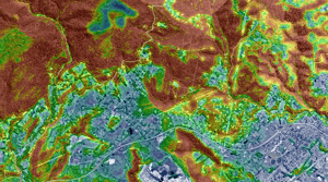
Mapping Urban Heat: A Data-Driven Approach to Climate Resilience
Why Urban Heat and Tree Canopy Mapping Matter for Councils Urban areas are heating faster ...
Scaling Innovation through Relationships
Technology Alone Does Not Build Resilience — Trust Does In development aid, especially ...
Monitoring Forest Clearing Using Satellite Data and AI-Derived Vegetation Height
Understanding how vegetation changes over time is essential for managing forests, ...
Tracking Vegetation Change: Geoneon’s Mapping of Tasmania’s Vegetation
Understanding how vegetation changes over time is important for environmental management, ...
Bushfires in Northwest Tasmania: How Sentinel-2 and SWIR Can See Through the Smoke
Using a real-world case study from northwest Tasmania to demonstrate the power of ...
Mapping Tasmania’s Vegetation Height: A New 10m Resolution Dataset
Vegetation height plays a critical role in understanding landscape dynamics, wildfire ...
Height Estimation from Aerial Visual Images with Deep Learning
You have collected a huge amount of high-resolution aerial visual images from your drones ...