Satellite data have become a valuable tool in understanding and mitigating the impacts of natural disasters. With advancements in technology, different types of satellite data have emerged, each with its own unique strengths and limitations. In this blog post, we will provide a review of the different types of satellite data, including optical, radar, thermal infrared, hyperspectral, and lidar, and examine their applications in disaster risk reduction.
Satellite data refers to data collected by sensors on satellites that are designed to capture information about the Earth's surface, atmosphere, and oceans. There are several different types of remote sensing data that can be acquired by satellites, including:
- Optical Data: This type of data is collected by sensors that detect visible and near-infrared light, such as cameras. It is used to create images of the Earth's surface, which can be used for applications such as mapping land cover, monitoring crops, and detecting changes in land use.
- Radar Data: This type of data is collected by sensors that emit radar waves and measure the reflected signal. Radar data can penetrate clouds and can be used to create images of the Earth's surface, even in conditions where optical data is not available. It is used for applications such as mapping topography, measuring ice thickness, and detecting changes in land cover.
- Thermal Infrared Data: This type of data is collected by sensors that detect heat energy. It is used to measure temperature and monitor the Earth's surface, atmosphere, and oceans. Applications of thermal infrared data include monitoring crop health, detecting changes in land use, and monitoring the temperature of the oceans.
- Hyperspectral Data: This type of data is collected by sensors that measure the reflectance of the Earth's surface across many narrow wavelength bands. Hyperspectral data can be used to identify the types of materials that make up the Earth's surface, such as minerals, vegetation, and water, and to monitor changes in land use.
- Lidar Data: This type of data is collected by sensors that emit laser light and measure the time it takes for the light to bounce back from the Earth's surface. Lidar data can be used to create highly accurate maps of the Earth's surface, including topography and vegetation structure.
These are some of the main types of remote sensing data that can be acquired by satellites. The type of remote sensing data that is collected depends on the specific mission and sensors of the satellite.
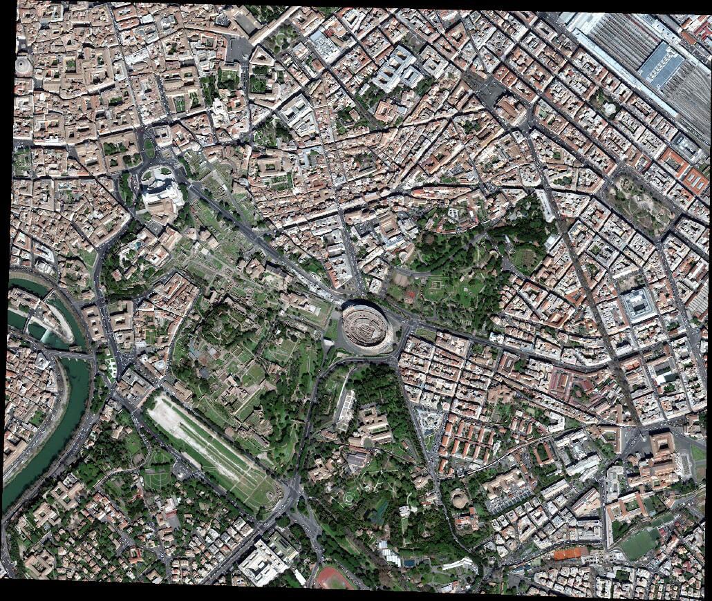
Example of optical satellite data, © Maxar Technologies.
Optical Data
Optical data collected using cameras mounted on satellites refer to digital images captured by cameras on satellites that are orbiting the Earth. These cameras take pictures of the Earth's surface, capturing images of the terrain, bodies of water, vegetation, cities, and other features. This type of data is collected to help organisations, governments, and researchers better understand the Earth's surface and how it is changing over time. The data collected by these satellites can be used for a variety of purposes, including monitoring changes in land use, predicting weather patterns, managing natural resources, and responding to natural disasters. The information collected by these cameras is transmitted back to the ground where it can be analysed and used for various applications.
Here are a few examples of the application of optical data collected from satellites for disaster risk reduction:
- Monitoring and predicting natural disasters: Optical data from satellites can be used to monitor and predict natural disasters, such as hurricanes, earthquakes, and tsunamis, by providing information about the location, size, and trajectory of these events.
- Assessing damage after a disaster: After a disaster, optical data collected from satellites can be used to quickly assess the damage caused. This information can help first responders prioritize their efforts and determine which areas need the most help.
- Identifying vulnerable communities: Optical data can be used to identify communities that are at a high risk of being affected by a disaster. This information can help government agencies and aid organizations develop disaster preparedness and response plans.
- Mapping and modelling risk: Optical data can be combined with other data sources, such as topographic maps and demographic information, to create detailed maps and models of disaster risk. This information can be used to help communities prepare for and respond to disasters more effectively.
- Monitoring land use changes: Optical data can also be used to monitor changes in land use, such as urbanization, deforestation, and land degradation, which can contribute to the risk of disasters.
- Disaster response and relief: Optical data can be used to support disaster response and relief efforts by providing information about the extent and location of damage, as well as the number and location of affected populations.
These are just a few examples of how optical data collected from satellites can be used for disaster risk reduction. The ability to monitor the Earth's surface from space provides valuable information that can help us better understand and respond to natural disasters, reduce risk, and protect communities.
It’s important to consider the various satellites that are dedicated to acquiring optical data. Here are some satellites that primarily acquire optical data:
- Landsat series: This series of satellites has been collecting optical data for over 40 years and provides some of the most detailed information available about the Earth's surface.
- Sentinel-2: This satellite, part of the European Space Agency's Copernicus program, provides high-resolution optical data for land and coastal zones.
- PlanetScope: This constellation of satellites provides high-resolution optical data for a variety of applications, including disaster risk reduction, environmental monitoring, and urban planning.
- SkySat: This constellation of satellites, owned by Planet, provides high-resolution optical data for a variety of applications, including agriculture, energy, and infrastructure.
- WorldView series: This series of satellites provides high-resolution optical data for a variety of applications, including defence and intelligence, environmental monitoring, and disaster response.
- QuickBird: This satellite, which was operated by DigitalGlobe, provided high-resolution optical data for a variety of applications, including urban planning, environmental monitoring, and disaster response.
- GeoEye series: This series of satellites, which was also operated by DigitalGlobe, provided high-resolution optical data for a variety of applications, including urban planning, environmental monitoring, and disaster response.
- RapidEye: This constellation of satellites, which was operated by BlackBridge, provided high-resolution optical data for a variety of applications, including agriculture, forestry, and environmental monitoring.
- SPOT series: This series of satellites, operated by Airbus Defence and Space, provides high-resolution optical data for a variety of applications, including agriculture, environmental monitoring, and disaster response.
These are just a few examples of satellites that primarily acquire optical data. The use of optical data collected from satellites is becoming increasingly widespread and provides valuable information for a variety of applications.
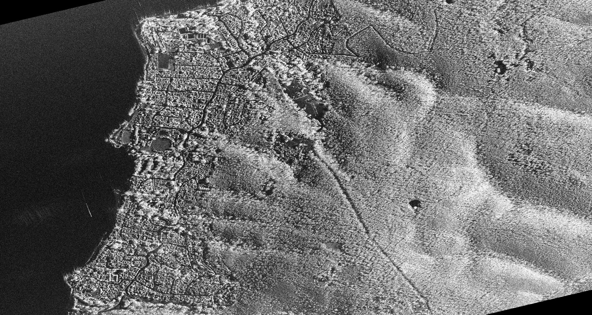
Example of Satellite radar data, © DLR.
Radar Data
Radar data collected using sensors mounted on satellites is information gathered by using radar technology to bounce radio waves off the Earth's surface and measure the reflections. This data can be used to create images and maps of the Earth's surface, as well as to gather information about the topography, vegetation, and other features of the land.
Radar data is unique compared to optical data, as it can be collected at any time, regardless of whether it is day or night, or whether there are clouds or other obstructions in the sky. This makes it a valuable tool for monitoring and understanding changes in the Earth's surface, as well as for responding to disasters and other emergencies.
In simple terms, radar data collected from satellites provides a detailed view of the Earth's surface, including information about its topography, land use, and changes over time, which can be useful for a variety of applications, including disaster risk reduction, environmental monitoring, and urban planning.
Here are a few real-life examples of the application of radar data collected from satellites for disaster risk reduction:
- Flood Monitoring: Radar data can be used to monitor changes in the Earth's surface and detect signs of flooding. This information can be used to create flood maps, predict the extent of flooding, and help emergency responders and disaster relief organizations better respond to floods and other disasters.
- Landslide Monitoring: Radar data can be used to monitor changes in the Earth's surface and detect signs of landslides. This information can be used to predict the likelihood of a landslide and help communities prepare for and respond to these events.
- Earthquake Monitoring: Radar data can be used to monitor changes in the Earth's surface and detect signs of earthquakes. This information can be used to create maps of the affected areas, estimate the magnitude of the earthquake, and help disaster response teams respond to the event.
- Wildfire Monitoring: Radar data can be used to monitor changes in the Earth's surface and detect signs of wildfires. This information can be used to create maps of the affected areas, predict the extent of the wildfire, and help disaster response teams respond to the event.
- Drought Monitoring: Radar data can be used to monitor changes in the Earth's surface and detect signs of drought. This information can be used to create maps of the affected areas, predict the extent of the drought, and help communities prepare for and respond to these events.
These are just a few examples of how radar data collected from satellites can be used for disaster risk reduction. The use of radar technology in disaster response is growing and provides valuable information that can help communities better prepare for and respond to disasters and other emergencies.
Given the increasing use of radar data in disaster response, it's worth noting the satellites that are dedicated to acquiring this type of information. Here are a few examples of satellites that primarily acquire radar data:
- TerraSAR-X & TanDEM-X.
- RADARSAT Series.
- COSMO-SkyMed.
- ALOS Series.
- Sentinel-1A & Sentinel-1B.
- RISAT and EOS Series.
The use of radar data in Earth observation and remote sensing is growing. These are just a few of the many satellites that use radar technology to collect data about the Earth's surface.
Example of satellite thermal data, © NASA and USGS.
Thermal Infrared Data
Thermal infrared data collected using sensors mounted on satellites is information gathered by using thermal infrared technology to measure the temperature of the Earth's surface. Thermal infrared sensors detect the heat that is emitted by the Earth's surface, which can provide information about temperature patterns, vegetation health, and other features of the land.
Thermal infrared data collected from satellites provides information about the temperature of the Earth's surface, which can be used to understand and monitor changes in temperature patterns, as well as to assess the health of vegetation and other features of the land. This information can be useful for a variety of applications, including disaster risk reduction, environmental monitoring, and urban planning.
Here are a few use-cases of the application of thermal infrared data collected from satellites for disaster risk reduction:
- Forest Fire Detection: Thermal infrared data can be used to detect signs of forest fires. This information can be used to create maps of the affected areas, predict the extent of the fire, and help disaster response teams respond to the event.
- Flood Monitoring: Thermal infrared data can be used to monitor changes in temperature patterns and detect signs of flooding. This information can be used to predict the extent of flooding and help emergency responders and disaster relief organizations better respond to floods and other disasters.
- Drought Monitoring: Thermal infrared data can be used to monitor changes in temperature patterns and detect signs of drought. This information can be used to create maps of the affected areas, predict the extent of the drought, and help communities prepare for and respond to these events.
- Urban Heat Island Analysis: Thermal infrared data can be used to measure the temperature of urban areas, which can provide information about the impact of the urban heat island effect. This information can be used to better understand the impact of urbanization on the environment, and to inform urban planning efforts.
- Volcano Monitoring: Thermal infrared data can be used to monitor changes in temperature patterns and detect signs of volcanic activity. This information can be used to predict the likelihood of an eruption and help disaster response teams respond to the event.
These are just a few examples of how thermal infrared data collected from satellites can be used for disaster risk reduction. The use of thermal infrared technology in disaster response is growing and provides valuable information that can help communities better prepare for and respond to disasters and other emergencies.
Here are some satellites that acquire primarily thermal infrared data:
- Landsat-7 ETM+.
- Landsat-8 OLI & TIRS.
- MODIS (Moderate Resolution Imaging Spectroradiometer).
- AVHRR (Advanced Very High-Resolution Radiometer).
- SMOS (Soil Moisture and Ocean Salinity).
- AMSR-E (Advanced Microwave Scanning Radiometer).
- SMOS (Soil Moisture Ocean Salinity).
These are just a few of the many satellites that use thermal infrared technology to collect data about the Earth's surface.
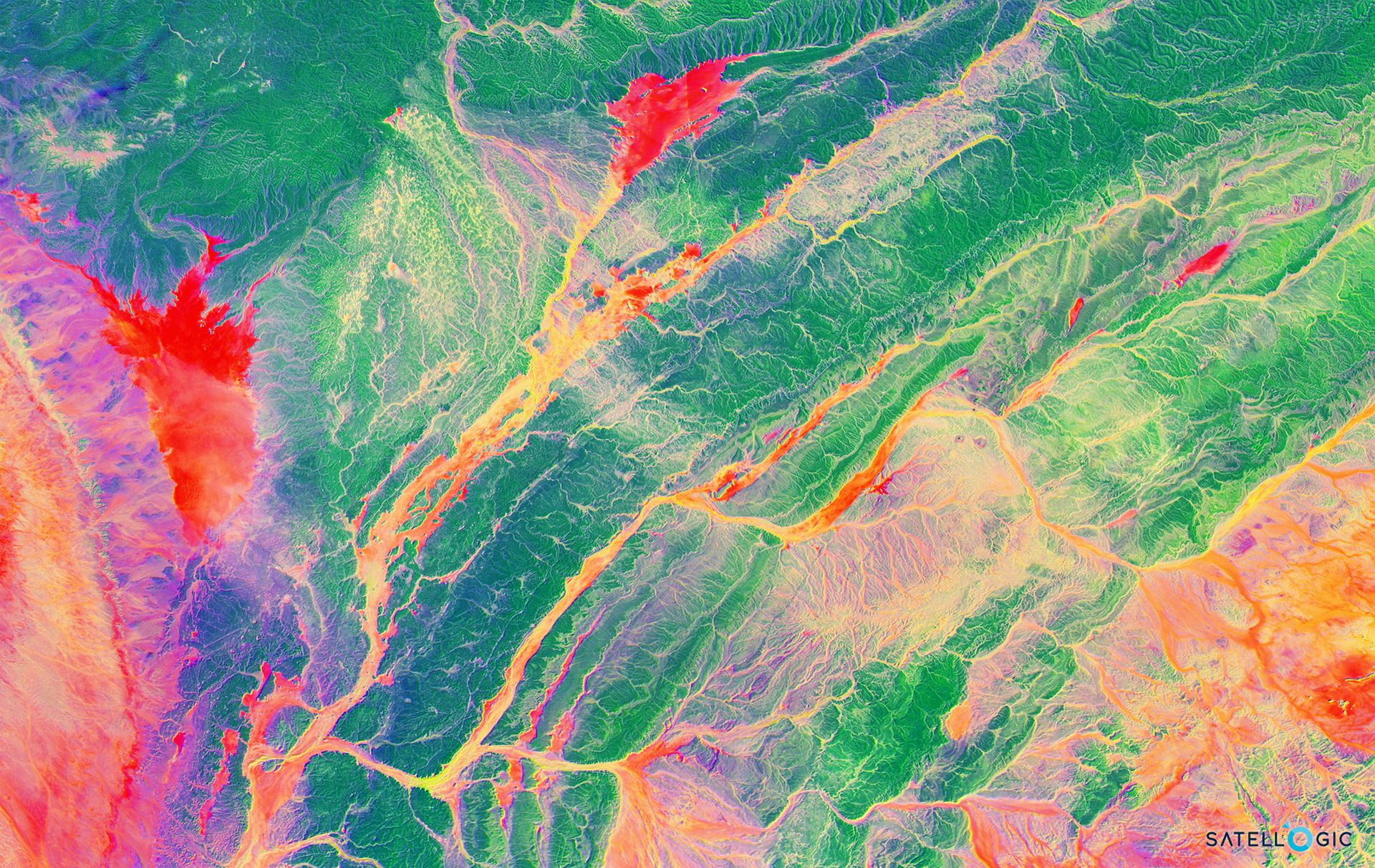
Example of satellite hyperspectral data, © Satellogic
Hyperspectral Data
Hyperspectral data collected using sensors mounted on satellites is information gathered by using hyperspectral imaging technology to measure the electromagnetic spectrum of the Earth's surface. Hyperspectral sensors can detect hundreds of different wavelengths of light, which can provide detailed information about the chemical and physical properties of the Earth's surface.
In simple terms, hyperspectral data collected from satellites provides information about the chemical and physical properties of the Earth's surface, which can be used to identify different types of materials and understand the environment. This information can be useful for a variety of applications, including environmental monitoring, resource management, and disaster risk reduction.
Here are a few real-life examples of the application of hyperspectral data collected from satellites for disaster risk reduction:
- Natural Disaster Response: Hyperspectral data can be used to assess the extent of damage caused by natural disasters, such as earthquakes, hurricanes, and wildfires. This information can be used to create detailed maps of the affected areas, predict the spread of the disaster, and help disaster response teams respond to the event.
- Flood Monitoring: Hyperspectral data can be used to monitor changes in the Earth's surface and detect signs of flooding. This information can be used to predict the extent of the flood and help emergency responders and disaster relief organizations better respond to floods and other disasters.
- Oil Spill Detection: Hyperspectral data can be used to detect the presence of oil spills on the Earth's surface. This information can be used to quickly respond to oil spills and help clean up the affected areas.
- Land Use/Land Cover Analysis: Hyperspectral data can be used to analyse land use and land cover patterns, which can provide information about the distribution of different types of vegetation, water bodies, and urban areas. This information can be used to better understand the impact of human activities on the environment, and to inform disaster risk reduction efforts.
- Soil Moisture Monitoring: Hyperspectral data can be used to monitor changes in soil moisture, which can provide information about the likelihood of drought and other natural disasters. This information can be used to predict the extent of the disaster, and help communities prepare for and respond to these events.
These are just a few examples of how hyperspectral data collected from satellites can be used for disaster risk reduction. The use of hyperspectral technology in disaster response is growing and provides valuable information that can help communities better prepare for and respond to disasters and other emergencies.
Here are some satellites that acquire primarily hyperspectral data:
- Hyperion (EOS).
- AVIRIS (Airborne Visible Infrared Imaging Spectrometer).
- PRISMA (PRISMA Hyperspectral Mission).
- CHRIS (Compact High Resolution Imaging Spectrometer).
- HySpec (Hyperspectral Environmental Suite).
- EnMAP (Environmental Mapping and Analysis Program).
- HyspIRI (Hyperspectral Infrared Imager).
- GRSS Hyperion (GeoResearch Space System).
- S-NPP VIIRS (Suomi National Polar-Orbiting Partnership Visible Infrared Imaging Radiometer Suite).
- APEX (Atmospheric Pretask for Earth Observation).
These are just a few of the many satellites that use hyperspectral technology to collect data about the Earth's surface.
Lidar Data
Lidar data is collected using sensors mounted on satellites that use laser technology to measure the distance to objects on the Earth's surface. The lidar sensors emit pulses of laser light that bounce off the surface of the Earth and are then collected by the sensors. This data can be used to create elevation maps and 3D models of the Earth's surface, which can provide valuable information for a wide range of applications, including disaster risk reduction, environmental monitoring, and resource management.
Lidar data is particularly useful for understanding the topography of an area, as it provides detailed information about the height and shape of objects on the Earth's surface. This information can be used to better understand the impact of natural disasters such as floods, earthquakes, and landslides, and to inform disaster risk reduction efforts.
In simple terms, lidar data is a type of remote sensing data that uses laser technology to measure the distance to objects on the Earth's surface and create detailed maps and 3D models of the environment.
Here are a few real-life examples of the application of lidar data collected from satellites for disaster risk reduction:
Flood mapping: Lidar data can be used to create maps of flood-prone areas, providing valuable information for disaster risk management and response efforts.
Landslide mapping: Lidar data can be used to identify areas at risk of landslides and to monitor changes in topography over time, providing important information for disaster risk reduction efforts.
Tsunami modelling: Lidar data can be used to model the impact of tsunamis and to understand how these events may impact coastal communities, providing important information for disaster risk reduction efforts.
These are just a few examples of how lidar data collected from satellites can be used for disaster risk reduction. The 3D modelling capabilities of lidar data make it an increasingly valuable tool for understanding and reducing the impact of natural disasters.
here are some of the major satellite missions that have used or are using lidar technology for various applications, including remote sensing and disaster risk reduction:
- Ice, Cloud, and land Elevation Satellite (ICESat-2)
- European Space Agency's CryoSat-2
- JAXA's Advanced Land Observing Satellite (ALOS)
- CNES's AltiKa
- Global Ecosystem Dynamics Investigation (GEDI), now attached to the International Space Station.
Conclusion
In conclusion, satellite data has become a critical tool in the field of disaster risk reduction, providing valuable information about the environment and the factors that contribute to natural disasters. There are several types of satellite data, including optical, radar, thermal infrared, hyperspectral, and lidar data, each of which has its own unique characteristics and applications.
Optical data provides high-resolution images of the Earth's surface and is used to monitor changes in land use, urban growth, and the spread of natural disasters. Radar data can penetrate clouds and provide information about the topography of the land, as well as the movements of objects, such as vehicles and ships. Thermal infrared data can be used to monitor changes in temperature, which can help to anticipate the spread of wildfires and track the movements of hurricanes and typhoons. Hyperspectral data provides detailed information about the chemical and physical properties of the Earth's surface, allowing scientists to identify different types of vegetation and minerals. Lidar data can provide precise measurements of the topography of the land, making it useful for creating detailed maps and identifying areas that are at risk of flooding and landslides.
By combining these different types of satellite data with other sources of information, such as ground-based measurements and computer models, we can gain a more comprehensive understanding of the factors that contribute to natural disasters and their potential impact. This information can then be used to support decision-making and planning efforts aimed at reducing the risk of harm to communities and the environment.
In this blog post, we have reviewed some of the main types of satellite data and their applications in disaster risk reduction. While satellite data is a valuable tool, it is important to remember that it is just one piece of the puzzle and that other factors, such as human actions and the environment, also play a critical role in shaping the outcome of natural disasters.