Harnessing Geospatial Technologies and AI for Resilient Development in Southeast Asia
Last week, the Asian Disaster Preparedness Centre (ADPC), the Swiss Agency for ...
Roxane Bandini-Maeder Named 2025 Tasmania Pearcey Entrepreneur of the Year
We are thrilled to share that Roxane Bandini-Maeder, Co-Founder and CEO of Geoneon, has ...
Geoneon Named Among Top 10 Global Resilience Solutions in the QBE AcceliCITY Challenge
We are proud to share that Geoneon has been selected as one of the Top 10 finalists ...
Geoneon Selected for AWS Space Accelerator: APJ 2025
We are excited to share that Geoneon has been accepted into the AWS Space Accelerator: ...
Geoneon Wins Technology Award at the 2025 Tasmanian Export Awards
We are delighted to share that Geoneon has won the Technology category at the 31st ...
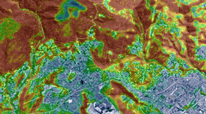
From Blocks to Buildings: EO + AI for Indonesia’s National Hazard Mapping
A field report from BNPB Jakarta — with a research blueprint for scaling KRB using event ...
Geoneon Named to Top 50 in Global QBE AcceliCITY Resilience Challenge
We are excited to share that Geoneon has advanced to the Top 50 in the QBE AcceliCITY ...
Geoneon Joins EnergyLab’s Climate Solutions Accelerator
We are delighted to share that Geoneon has been selected for EnergyLab’s 2025 Climate ...
Reflections from the South Asia Dialogue on Climate Resilience
Last week, Roxane Bandini-Maeder, CEO and Co-Founder of Geoneon, was invited to attend ...