Hobart, Tasmania – Geoneon, a leader in geospatial technology and climate risks, is proud to announce the launch of its revolutionary platform dedicated to assessing bushfire exposure in the Greater Hobart area. This platform marks a significant advancement in bushfire risk assessment and community safety.
Funded by the National Emergency Management Agency of the Australian Government and developed in collaboration with the local councils of Hobart, Kingborough, and Glenorchy, and emergency services, this cutting-edge platform utilises advanced deep-learning algorithms and geospatial data to provide an unprecedented Bushfire Exposure Index. This tool is designed to provide updates, granting local governments, residents, and emergency services clear insights into their bushfire risk exposure. Additionally, it enables the tracking of progress in achieving bushfire mitigation goals within their respective areas.
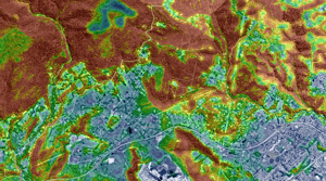
Key Features of the Platform:
- Bushfire Hazard Severity Index: Providing a comprehensive assessment of potential bushfire threats based on various factors such as vegetation density and topography.
- Bushfire Exposure Index: Ranging from 'Minimal' (1) to 'Extremely High' (10), offering a nuanced understanding of bushfire risks.
- Interactive Mapping: Visual representation of bushfire exposure levels across Greater Hobart, with user-friendly navigation.
- Community-Centric Design: Tailored to assist residents in understanding and preparing for bushfire risks.
Key Benefits of the Platform for Greater Hobart:
- Strengthening mitigation strategies and emergency responsiveness
- Enhancing community engagement and risk awareness
- Informing sustainable community recovery and resilience building
- Educating new residents about climate hazards and preventive measures
- Optimising resource allocation and prioritising needs
- Refining risk assessments for greater accuracy
- Support to update emergency operation plans with the latest data insights
Launching the Platform in Hobart today on behalf of the Federal Government, Assistant Minister for Infrastructure Senator the Hon. Carol Brown welcomed this critical advancement for Tasmanians.
“The Albanese Government is committed to ensuring Australian communities are better prepared for natural disasters, so we can respond and recover faster, stated Senator Carol Brown. “Increased rainfall has led to a surge in vegetation growth right around Tasmania, which means our communities, both rural and urban are more at risk than ever before. The Greater Hobart Bushfire Exposure Index will provide our emergency services and communities with critical information for the upcoming bushfire season and beyond.”
Lord Mayor of Hobart, Anna Reynolds said that the platform will be a huge benefit for Greater Hobart.
“As Hobart prepares for a challenging bushfire season, the Geoneon platform is a vital addition to our city's resilience efforts,” said Anna Reynolds, Lord Mayor of Hobart. “With the heightened risk due to dry conditions and climate change, this tool will significantly aid our residents in understanding and preparing for bushfire threats. Our city is proactive in bushfire preparedness, investing in fuel reduction burns and maintaining fire breaks. The introduction of the Geoneon platform aligns perfectly with these efforts, enhancing our capability to safeguard our community. I encourage everyone to complement this tool with personal bushfire plans and emergency preparedness.”
“The launch of this platform is a milestone in our commitment to enhancing community resilience against bushfires,” said Roxane Bandini-Maeder, CEO at Geoneon. “By providing accurate, accessible, and comprehensive information about bushfire exposure, we aim to empower communities and local authorities in making informed decisions for safety and preparedness.”
The development of this platform is part of Geoneon’s broader initiative to leverage technology in disaster risk reduction. This initiative aligns with the Australian Government’s efforts to enhance emergency management and community resilience in the face of increasing bushfire threats.
Geoneon invites community members, local government officials, emergency responders, and all interested parties to explore the platform and utilise the resources available to better understand and prepare for bushfires in the Greater Hobart area.
For more information about the platform and to access the Bushfire Exposure Index, please visit https://hobart.geoneon.com/.