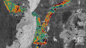
The Shire of Dundas, with the support of National Disaster Risk Reduction Grant Program, and in association with the Freight and Logistics Council of Western Australia engaged Geoneon to undertake a proof-of-concept project combining earth observation data, machine learning, and advanced modelling to:
✅ Conduct vegetation analysis and infrastructure identification.
✅ Analyse exposure and vulnerability of infrastructure and supply chains to wildfire.
Learn more here: https://blog.geoneon.com/en/blog/case-study-wildfire-impact-on-dundas-freight-supply-chain