Skip to content
Cover-Case-Study-Bhutan
Geoneon24 April 20243 min read

Case Study: Infrastructure Vulnerability to Climatic Disasters in Bhutan

CLIENT

The clients are the Asian Disaster Preparedness Center and the government of Bhutan, represented by the Department of Disaster Management and the Department of Roads. 

WHAT WE DID

  • Utilised very-high resolution and multi-band satellite data to assess the vulnerability of critical infrastructure to natural disasters such as landslides and floods. 
  • an infrastructure model based on replacement value metrics and detailed susceptibility maps for rockfalls, debris flows, large torrents, and floods. 
  • Analysed the potential impact on buildings, roads, and power lines using a vulnerability model at a 30-meter grid resolution, identifying hotspots most at risk. 
  • Provided actionable mitigation measures to local stakeholders to enhance resilience and reduce potential damages from future climatic events. 

PROJECT INFORMATION

Geoneon, in partnership with Terranum, took part in the Climate Innovation Challenge (CIC), a contest designed by the Asian Disaster Preparedness Center (ADPC) and supported by the Program for Asia Resilience to Climate Change funded by the UK Government and the World Bank. This initiative aimed to find innovative solutions for building resilience against climate change in South Asia, where Geoneon’s project was one of sixteen global innovations recognised for its potential impact out of 270 applicants. 

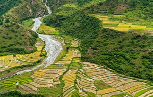
In the challenging terrains of the Phuentsholing - Pasakha and Gelephu watersheds in Bhutan, the project spanned approximately 400 square kilometres, employing state-of-the-art geo-analytical methodologies to strengthen regional resilience against natural disasters. 

Leveraging cutting-edge very-high resolution and multi-band satellite imagery, our team developed a sophisticated infrastructure vulnerability model. This approach allowed us to systematically assess and predict the impacts of hydro-geological hazards on critical infrastructures. 

Our innovative use of replacement value metrics in infrastructure modelling provided a quantifiable basis for economic risk assessment and mitigation planning. Complemented by our development of susceptibility maps for rockfalls, debris flows, large torrents, and floods, this dual approach facilitated a comprehensive hazard evaluation. 

We achieved detailed vulnerability modelling of buildings, roads, and power lines, utilising a 30-meter grid resolution. This granularity in data modelling supports targeted mitigation strategies and enhances the accuracy of intervention planning. 

These initiatives exemplify the integration of advanced geospatial technologies and data-driven strategies in disaster risk management. By transforming complex data sets into actionable intelligence, we empower policymakers and stakeholders to implement more effective resilience and adaptation measures. 


CHALLENGES

  • Accessing high-quality, high-resolution data in remote and rugged terrains was complex and required innovative satellite data solutions. 
  • Combining various data types, from satellite imagery to local infrastructure databases, posed significant integration challenges. 
  • Communicating technical findings to local stakeholders and ensuring their engagement in long-term mitigation strategies. 

RESULTS

The successful completion of this project not only supports Bhutan in its efforts to mitigate disaster risks but also sets a benchmark for similar initiatives worldwide, proving the efficacy of technology-driven solutions in enhancing infrastructure resilience against climate change. 

  • It provided valuable resources for the Department of Disaster Management, enhancing their ability to communicate risks and engage with local governments on mitigation strategies. 
  • Mitigation measures have been recommended to reduce potential damage and enhance resilience against future climatic events. 
  • The methodology developed can be applied globally, demonstrating a scalable and fast approach to identifying vulnerable infrastructure using advanced algorithms, including machine learning. 


BROWSE THE PROJECT MAPS

Gelephu

Phuentsholing - Pasakha

RELATED ARTICLES