Hobart, Tasmania – Geoneon, a pioneer in leveraging Artificial Intelligence (AI) and Earth Observation technologies, today announces the launch of its Vegetation Mapping solution. This innovative product is set to change the landscape of how vegetation cover is monitored, analysed, and managed across various sectors, including environmental conservation, urban planning, utilities, fire services, and agriculture.
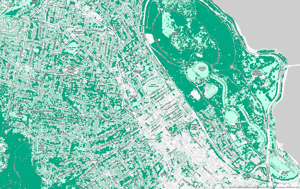
Geoneon's Vegetation Mapping harnesses the power of state-of-the-art satellite imagery and advanced AI to provide up to 30cm resolution mapping. This breakthrough allows for the precise identification and categorisation of vegetation globally, addressing the challenge of accurately mapping and monitoring vital natural resources. The product offers an accessible, high-resolution, and consistent approach to vegetation mapping, emphasising its critical role in maintaining ecological balance, supporting wildlife, and contributing to the global carbon cycle.
Key Features of Geoneon's Vegetation Mapping:
- High Accuracy: Utilises AI algorithms, validated by terrestrial and aerial reference data, to deliver unmatched precision in vegetation mapping.
- Scalability and Global Reach: Offers a scalable dataset with transparent pricing, enabling global coverage without the need for traditional, resource-intensive field measurements.
- Quick Turnaround: Employs AI-powered processing to accelerate mapping processes and provide fast, consistent updates.
- Seamless Integration: Designed for straightforward integration into any GIS workflow, facilitating ease of use without the necessity for complex system adjustments.
Geoneon's solution go beyond traditional limitations by leveraging Lidar-calibrated AI models. This approach harnesses high-resolution Lidar (Light Detection and Ranging) data, offering a new level of detail in vegetation mapping from expansive landscapes to individual trees.
"At Geoneon, we are dedicated to leveraging our technological expertise to aid in the comprehensive and accurate disclosure of climate physical risks and drive sustainability initiatives," said Roxane Bandini-Maeder, CEO at Geoneon. "Our Vegetation Mapping product is a testament to our commitment to providing innovative solutions that meet the needs of our diverse clientele across utilities, cities, government agencies, and international organisations."
In addition to its core features, Geoneon Vegetation Mapping stands out for its ability to provide continuous insights over time. By offering detailed analyses of both tree and low-lying vegetation changes across any landscape, this solution empowers stakeholders with the information needed for informed decision-making, strategic planning, risk assessment, and compliance monitoring.
Geoneon's Vegetation Mapping is now available for those ready to transform their approach to vegetation mapping with unparalleled precision and ease. For more information on the product or to download a sample, please visit the webpage or email the sales team directly.
About Geoneon:
Geoneon is an innovative technology firm focused on transforming complex geospatial data into actionable climate risk insights. By bridging the gap between environmental data and reporting, Geoneon aids in accurate climate risk disclosure and drives sustainability initiatives across utilities, cities, government agencies, and international organisations. To learn more visit www.geoneon.com or follow us on LinkedIn.