Geoneon Joins EnergyLab’s Climate Solutions Accelerator
We are delighted to share that Geoneon has been selected for EnergyLab’s 2025 Climate ...
Reflections from the South Asia Dialogue on Climate Resilience
Last week, Roxane Bandini-Maeder, CEO and Co-Founder of Geoneon, was invited to attend ...
Geoneon in Laos: Supporting Early Warning Systems through AI & Satellite Data
Earlier this month, Roxane Bandini-Maeder, CEO and Co-Founder of Geoneon, travelled to ...
Geoneon Wins 2025 TasICT Award for Top Tasmanian Tech Innovator
On June 27, 2025, Geoneon was honoured with the Top Tasmanian Tech Innovator or Start-up ...
Ambassador Siswo Pramono Visits Geoneon to Discuss Data-Driven Resilience
Last week, Geoneon welcomed the Ambassador of Indonesia to Australia, His Excellency ...
Geoneon Selected for QBE AcceliCITY Resilience Challenge 2025
We are excited to share that Geoneon has been selected as one of the Top 100 global ...
Geoneon Wins National Planning Award for Research Excellence
We are thrilled to announce that Geoneon, together with the University of Tasmania, WSP, ...
Geoneon Named Startup of the Year at the 2025 Australian Space Awards
On May 28 in Sydney, Geoneon was awarded Startup of the Year at the 2025 Australian Space ...
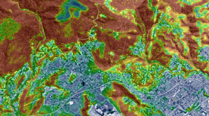
Mapping Urban Heat: A Data-Driven Approach to Climate Resilience
Why Urban Heat and Tree Canopy Mapping Matter for Councils Urban areas are heating faster ...